Ships and Vessels -
Find Ships and Vessels in your area or worldwide.
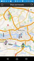
This app presents allows users to locate Ships and Vessels live on a map.
Just open the app, let it find your location and press the refresh button.
If any ships nearby with appropriate AIS transponders and a receiving station in our network is picking it up you should be able to see the ships on the map.
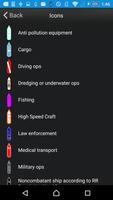
See the following ship/vessel details:
Update time
MMSI number
IMO number (Internation Maritime Organisation)
Ship Type (Passenger, cargo, pleasure, dive, military and many more)
Navigational status (under way, berthing, moored and many more)
Rate of Turn (when available)
Speed (kts)
Course
True Heading
Special Maneuvres
Latitude and Longitude
Destination port (call of port) when available
ETA (Estimated Time of Arrival) when available
Vessel Length (meters)
Vessel Width (meters)
Vessel Draught (meters)
To Bow (from AIS transponder)
To Stern (from AIS transponder)
To Port (from AIS transponder)
To Starboard (from AIS transponder)
We hope you enjoy the app please leave a good rating in order to keep us improving the app.
What's New in the Latest Version 2.1
Last updated on Sep 27, 2015 This new version introduces ship search functionality based on ship names. Furthermore, it lets the user see the ship details based on the information received from the AIS signals that the ship transmits.Ships found that have data older than 30 minutes will be shown as a red crosshair.
Furthermore, it fixes a minor problem with search functions found in earlier versions.